A Brighter Vision for Dog's Head
Austin just approved a 45-year development agreement on top of what could be one of the most important, and overlooked, water resources in Central Texas, for generations to come.

Hello dear friends and Austinites - something monumental has just happened for the city of Austin, and it’s not getting nearly enough attention. I’m so excited about this new development, and I hope you’ll let me explain why I’ve been rabidly talking about this for the last several weeks.
Austin has just annexed Dog’s Head.
The City of Austin has signed a contract to annex 2600 acres of land, making it part of Austin proper. A local developer, Endeavor, the group behind the Domain, had been gradually acquiring parcels in Dog’s Head.
On May 14th, the annexation was added to the May 21st city council meeting agenda, as Item 38. The meeting started at 8am, and after many speakers pled with the council to wait to sign the contract until more analysis could be done, at around 7:30pm the council voted unanimously to sign it. The reason for the rush, the necessity of such speed and lack of deliberation, was said to come from a prospective first tenant for the area, an unnamed Fortune 100 company. The overall vibe was “We need the city to say ‘Yes’, and sign this contract right now, so we can tell our client they have the green light, and we can iron out all the exact details for the rest of the space later.” The contract has a period of 45 years, the longest allowable by state law for this sort of deal, and the contract seemingly was authored entirely by the developer. It includes some high level bullet points that the City can tout as progress (10% open space, 20% affordable housing, continuation of the boardwalk/hike & bike trail), and grants the developers the right to proceed with development as they see fit, free from most of the usual inputs from the City of Austin, like impervious cover or height restrictions (whether these are essential guardrails for the safety, beautification, and longevity of our City, or are completely unnecessary bureaucratic hoops to jump through which are strangling the City with red tape, depends strongly on who you ask).
So, for now, the deal is done, the city will be annexing Dog’s Head, and Dog’s Head will stay annexed provided the city honors the contract as signed.
So… What is Dog’s Head?
Here is the rough area outlined in red, and you should see readily where it gets the name. Woof!
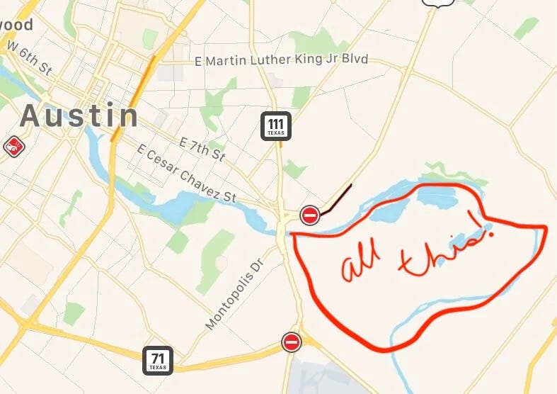
It’s easy to say simply:
Dog’s Head is a low-lying area surrounded on three sides by the Colorado river, downstream from Town Lake and the Longhorn dam. It has historically been used for industrial activities, where sand, gravel, and aggregate has been mined.
But, that’s not really what it is. To understand what Dog’s Head is, we need to take a step back and look at the city of Austin, Texas, and the landscape in which it lives.
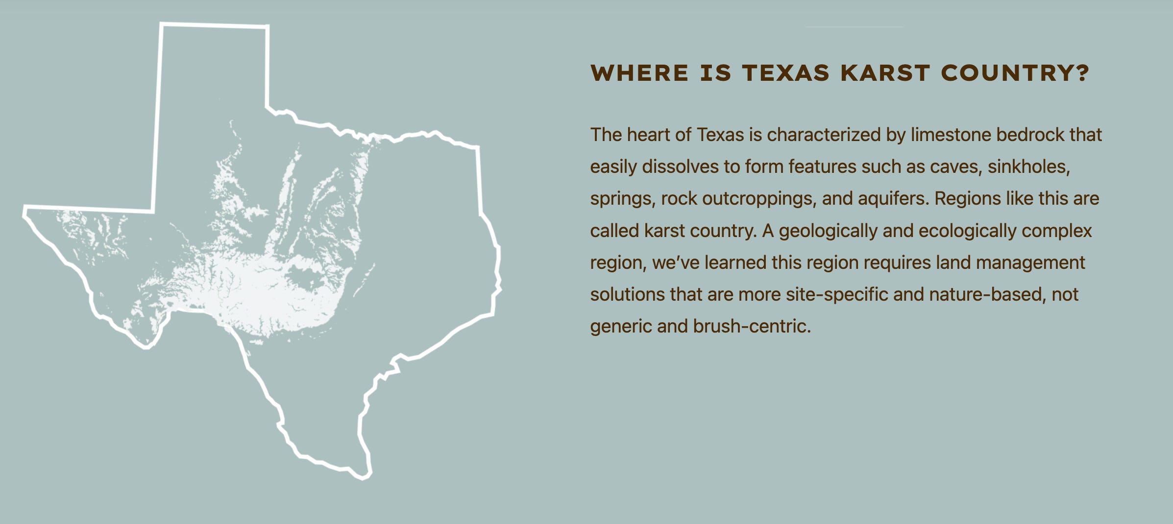
A brief look at Texas…
Despite prevailing popular perception internationally, Texas is not flat. In the southeast, we have lowlands going down to the Gulf. To the northwest, we have a high plateau, the Llano Estacado, or “staked plains”. Separating these two regions is the jagged Hill Country. In the far west of the state, the rugged Guadalupe Mountains spring forth, ancient coral reefs built by unimaginable generations of sea life, and in the far east we have dense piney woods and fertile blackland prairies.

Texas has always been defined by water. The original features of the landscape created by water, and now all modern life, cities, ecologies, and geographies defined by how water moves over and through those regions.
Here’s a beautiful look at how the water moves across our great state.

It should come as no surprise that this map closely matches the one above - water falls as rain, and makes it to the nearest river just as quickly as it can, and finds its way eventually down to the ocean. Here are what those major river watersheds look like:
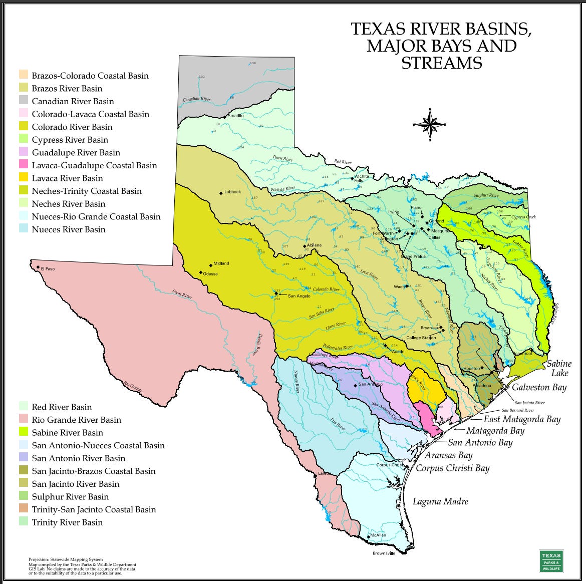
Take a moment and notice where the major cities are located - almost without exception, they are on or near a river. It goes without saying that Water is Life. Human survival requires water, and modern cities, industry, and agriculture, require a lot of water. When we first built cities, we placed them where the water already was.
But, this isn’t the whole story. Fairly early in the development of Texas as we know it now, we realized there was water not just in the rivers, which ebbed and flowed with capricious temperaments, but there was water in the ground. We not only found rivers sprouting from rock - artesian springs gushing forth with clear clean cold water, but also that almost anywhere you dug you’d quickly find a ready supply. (Native folks have definitely enjoyed the springs dating back over 10,000 years.)
This groundwater of course, comes from aquifers - vast underground areas that can hold water. Some hold ancient water deposited when dinosaurs roamed, or trapped from ancient seas, while others fill with rainwater that trickles down into them.
In Texas, for a city to survive, it needs to have a river, or an aquifer, or ideally - both.
Now that we’ve painted some broad strokes about the Texas backdrop…
Let’s talk about Austin.
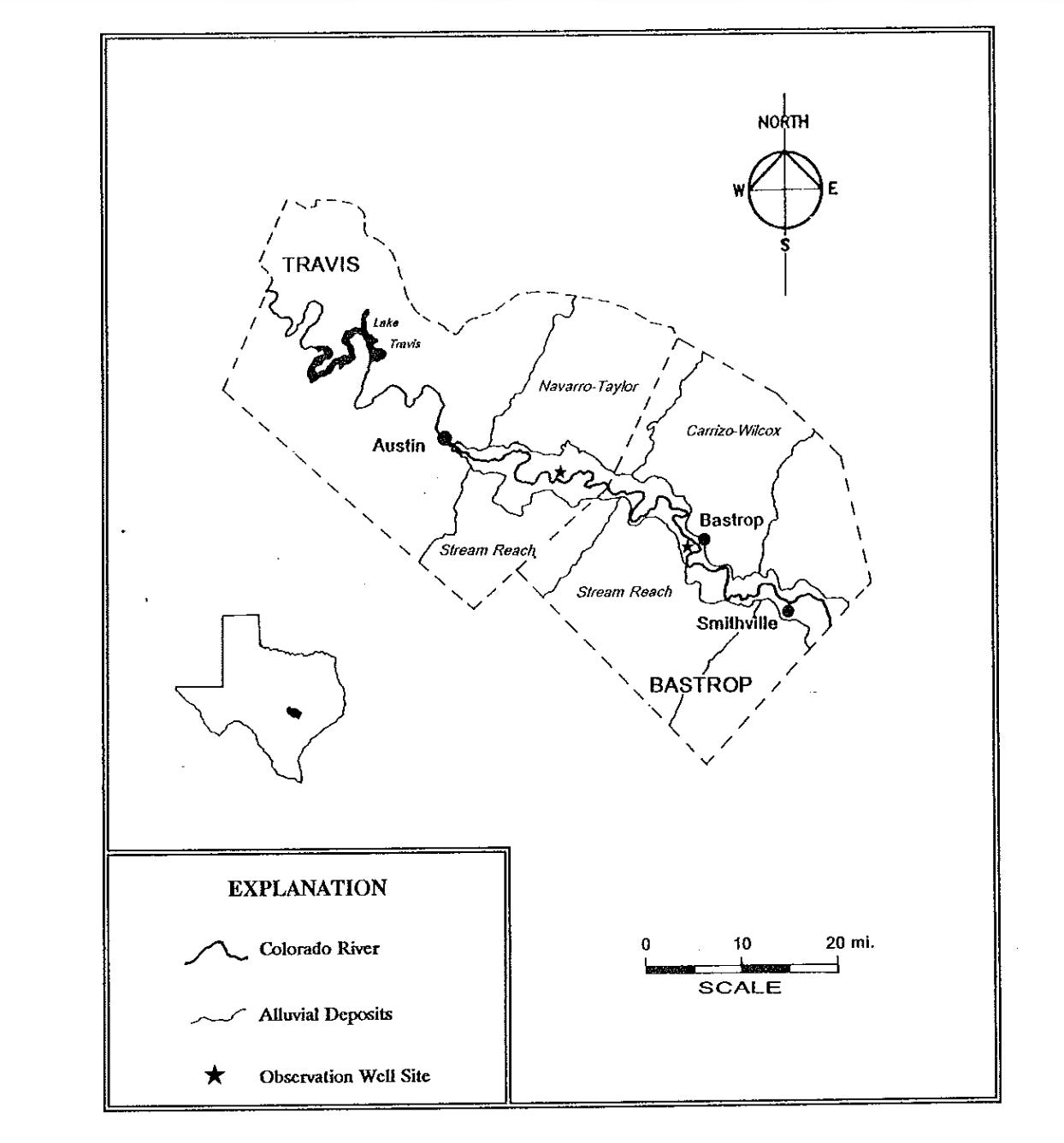
The City of Austin sits right in the foothills - where the rising Hill Country to the west opens up to the lowland plains to the east. It sits along the Colorado river, which is fed by the entire Colorado River Basin.
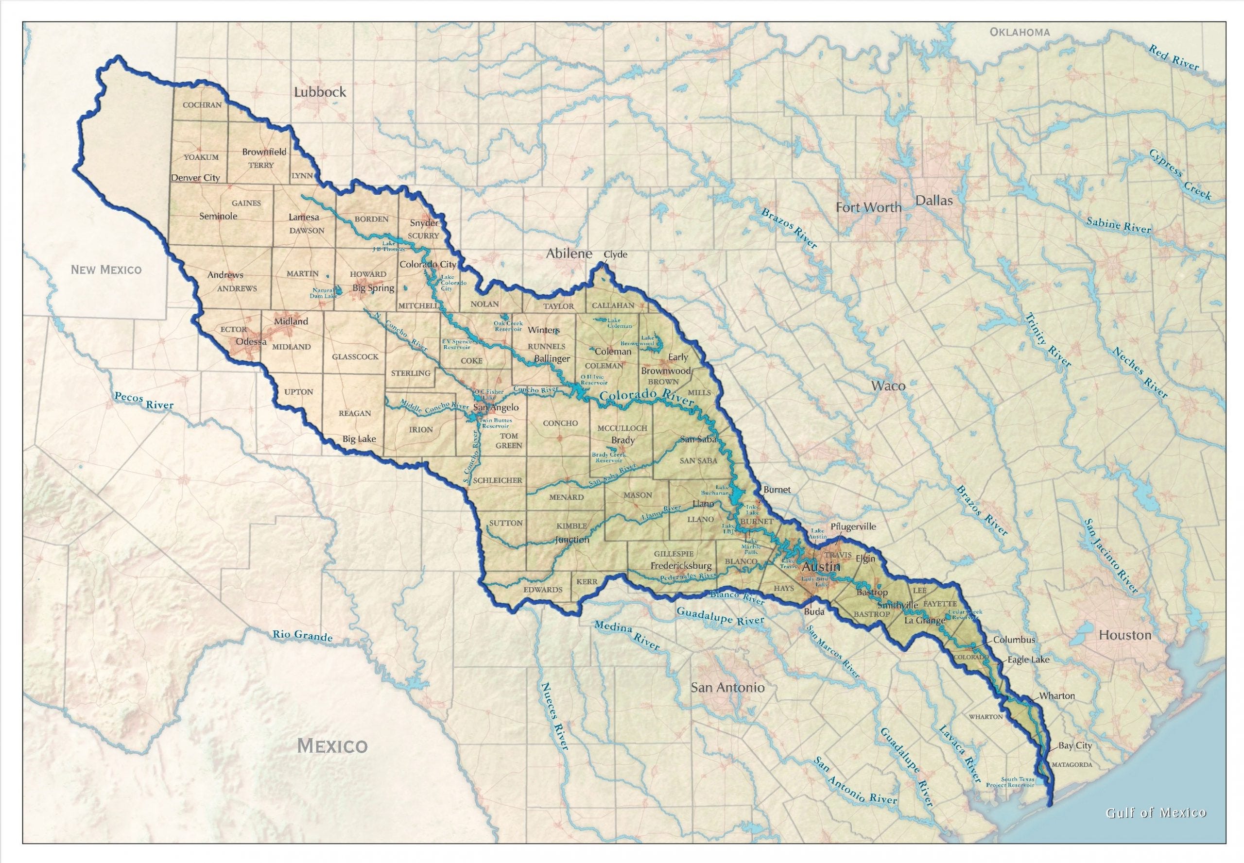
This river system has been shaped and crafted into the Seven Highland Lakes, which store water for the city to use whenever it’s needed.

Not only that, Austin sits at the convergence of several major aquifer systems. Due to a long history of conservation and activism, water continues to gush forth from Barton springs.
It’s hard for me to overstate how this is really good for Austin.
We’ve got reservoirs upstream, we’ve got one in the middle of town. We capture a huge area of rainwater, and have the capability to store it. Because we started protecting our aquifers 50 years ago, we still have natural springs and pretty solid aquifers that are able to recharge with rain. Compared to our neighbors, we, as a city, are doing mighty fine. Despite this, we will not escape the coming crisis.
We have major water problems in Texas.
Just 30 minutes north Georgetown is having major water issues, and trying to get water piped in from 200 miles east. San Marcos, Kyle, Buda, just 30 minutes south, are also facing major issues. Lakes are drying up, wells are running dry.
Sid Miller, the Texas Agricultural Commissioner, finally started talking about it.
“Texas is running out of water, and the crisis in Corpus Christi is the canary in the coal mine. Coastal communities like Corpus sit at the end of the line. When upstream supplies drop or saltwater pushes in, South Texas families, farmers, ports, and industries are the first to take the hit. This is a warning shot and ignoring it is not an option. […]
Water is the lifeblood of Texas. We must treat it like it matters. That means planning ahead, demanding accountability, enforcing our water rights, and investing now in the infrastructure that shields our communities from shortages. Texas cannot thrive without a strong, reliable water supply. Without water, nothing else works, not growth, not jobs, not agriculture, not security.
This is our moment to act. The price of waiting will be far higher.”
“We’re already out of water”, he states in this interview. He’s not being alarmist. We’re having major water issues throughout all of Texas today, and those problems are going to get bigger and more severe. Future water needs are projected to continue increasing, as more people move to the state, as more industry is built out, and as aquifers continue to deplete.
So…. what about Dog’s Head?
As we established earlier Dog’s Head is a low-lying area, a meander of the Colorado river. It’s just downstream from Longhorn dam, the final reservoir supplying our city. The sand, gravel, and aggregate mined here was used to build out the city itself. It’s in a floodplain, or rather - it is the floodplain.
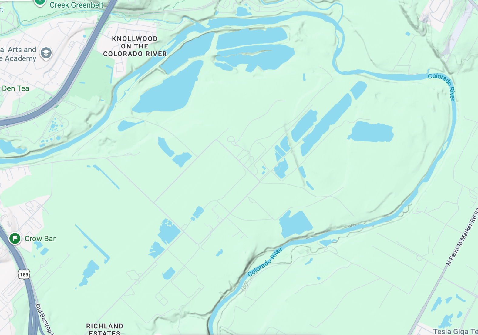
It’s barely populated at all. It’s hardly developed at all. It’s right next to downtown, it’s right next to the airport. It’s huge - 4 square miles.
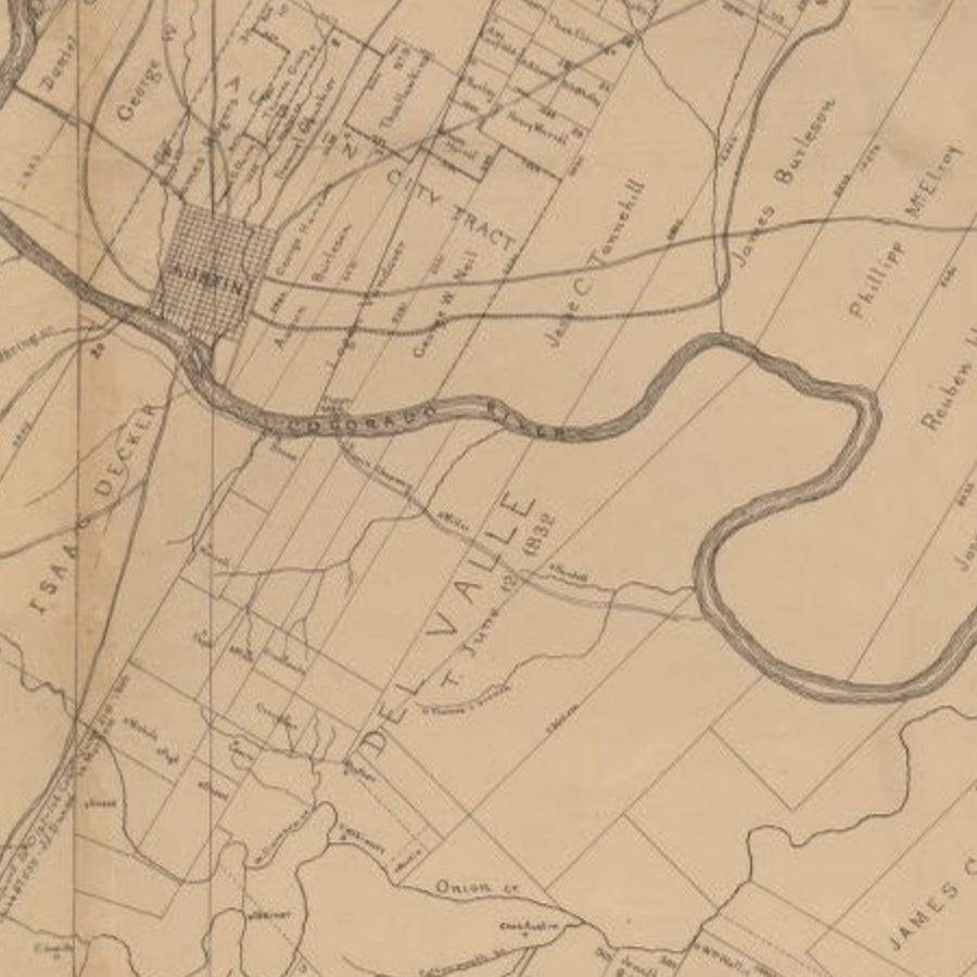
While the shape of rivers change over time, and over the last several thousand years the Colorado river has snaked back and forth over this area, this particular section has stayed relatively consistent since at least the 1880s.
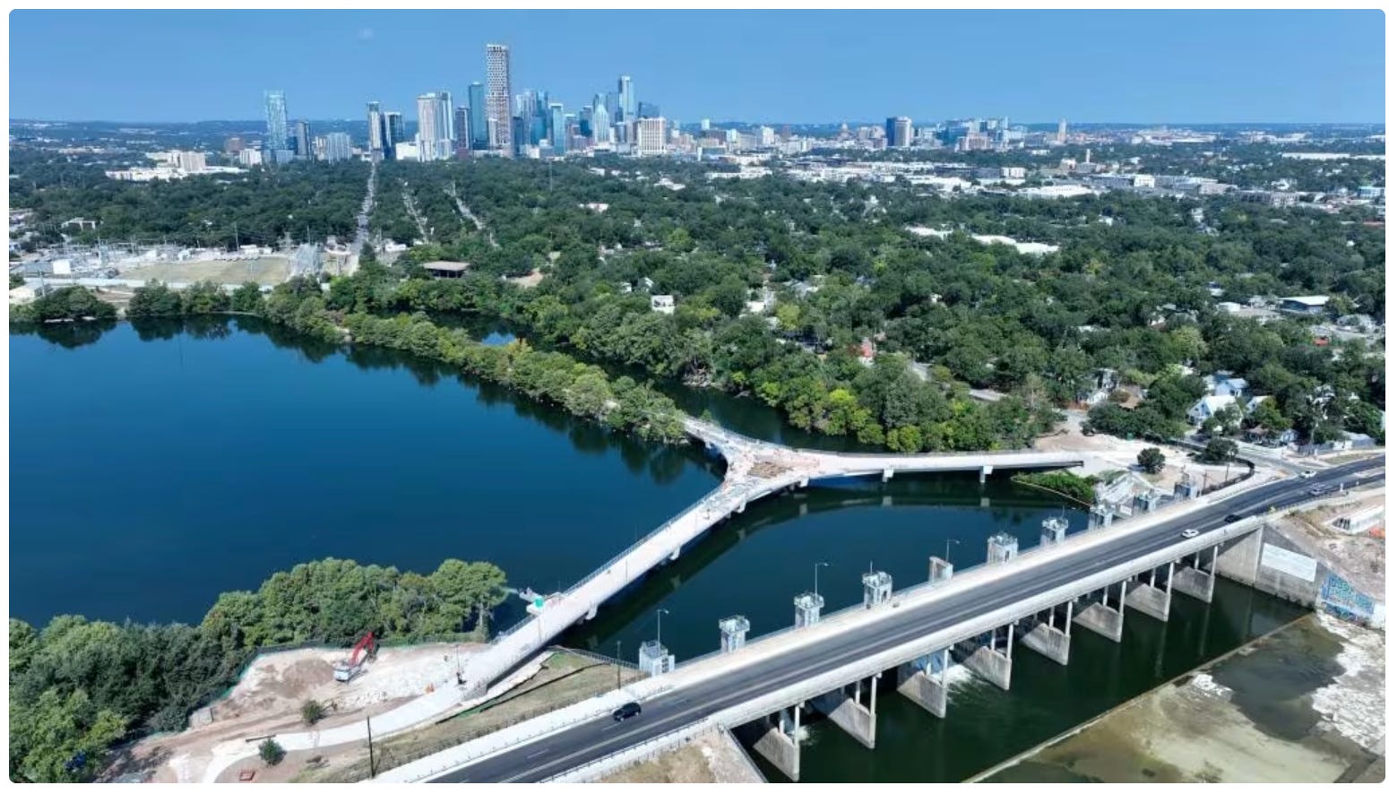
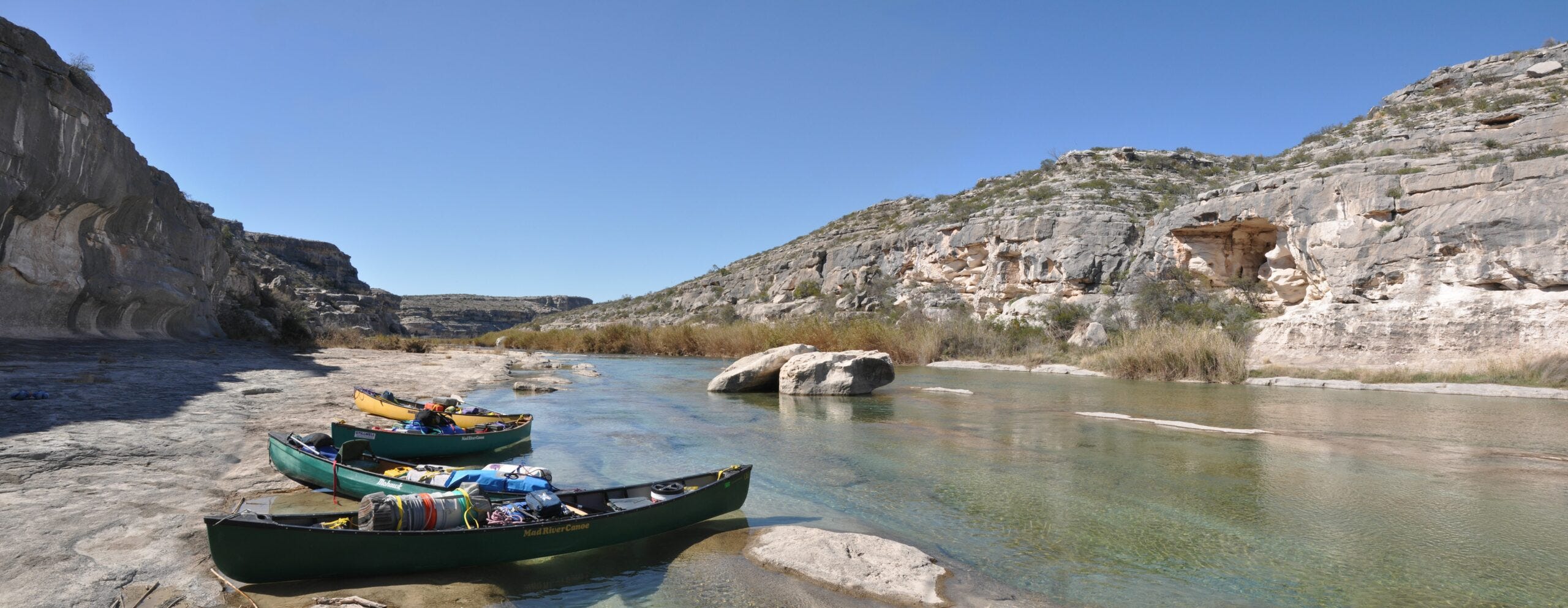
The river along this stretch is beautiful, it mostly looks like this:

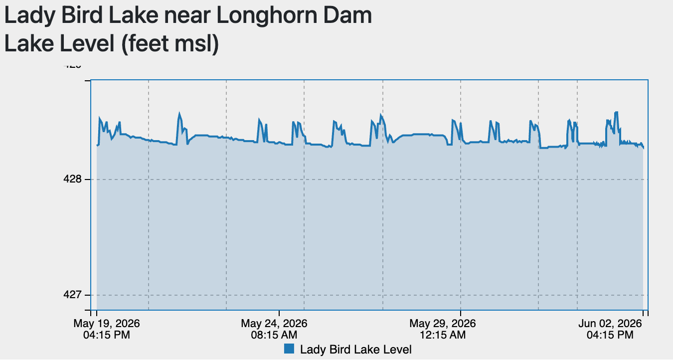
The longhorn dam, managed by Austin Water, pulses out releases from Town Lake, also called Lady Bird Lake (against her wishes).
Almost every evening there’s a release.
Whenever any new development is proposed in Austin, one of the first, and essential questions to ask is “How will this impact our water?”
This is an essential question to ask, and splinters into many more questions - will this cover an important area for aquifer recharge, will the buildings here create runoff and contribute to flooding downstream, will this site generate anything toxic that will infiltrate into groundwater, leach into surface water, or be swept away by floodwater?
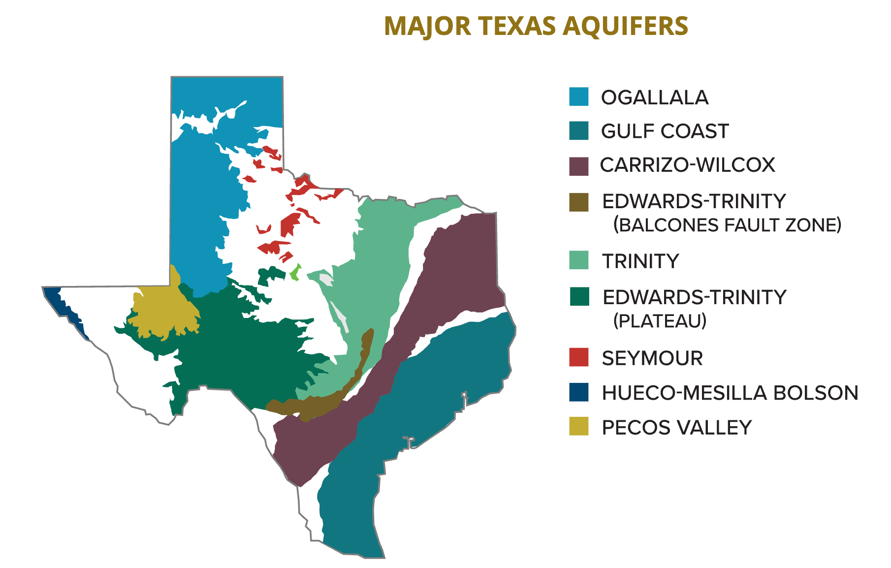
Most developments in Austin are over either the Edwards Aquifer, the Trinity Aquifer, or right in the Balcones Fault Zone. Texas Water Development Board (TWDB) maintains maps of aquifers, and wells.
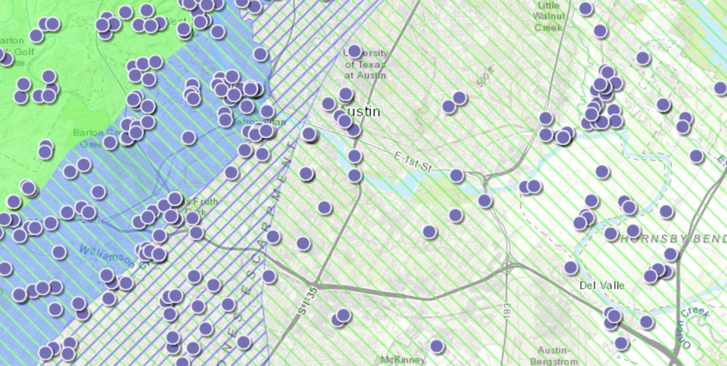
You can see that technically, Dog’s Head is in the Trinity Aquifer area - but, something starts to get a little strange when you look closer.
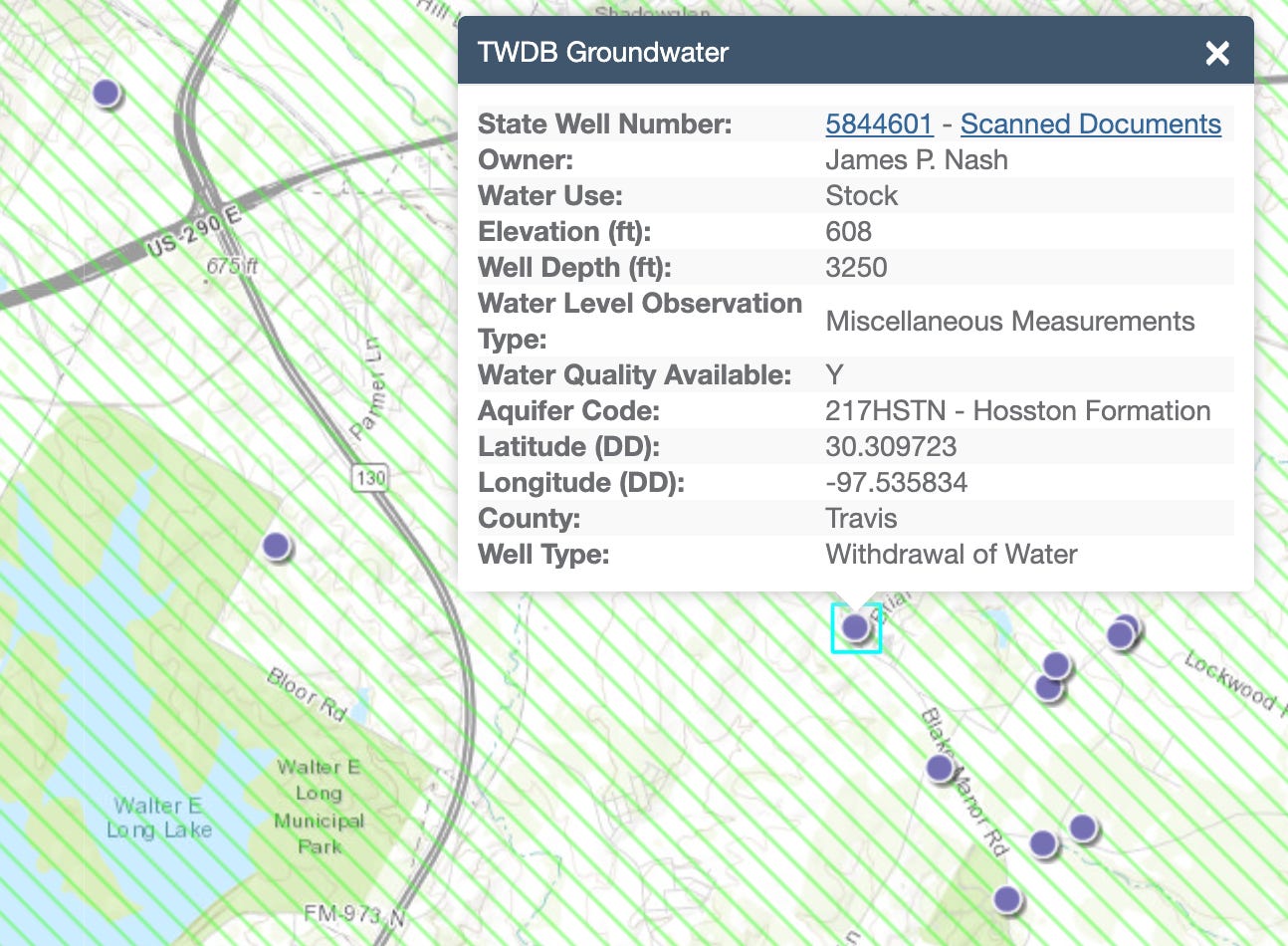
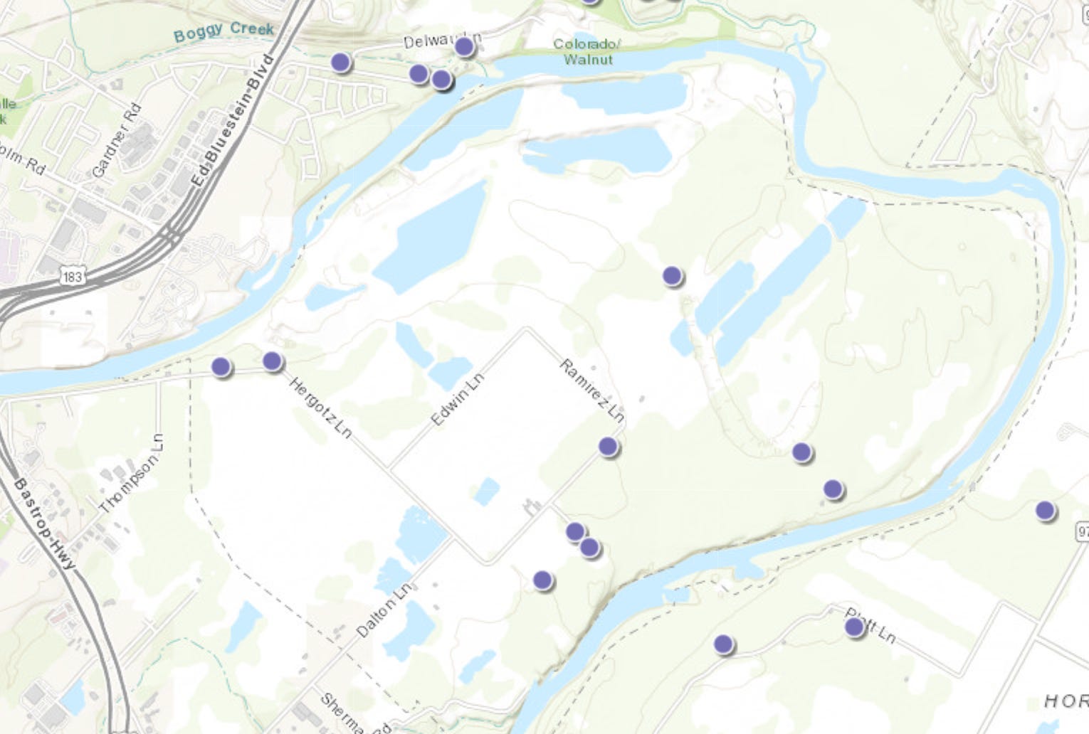
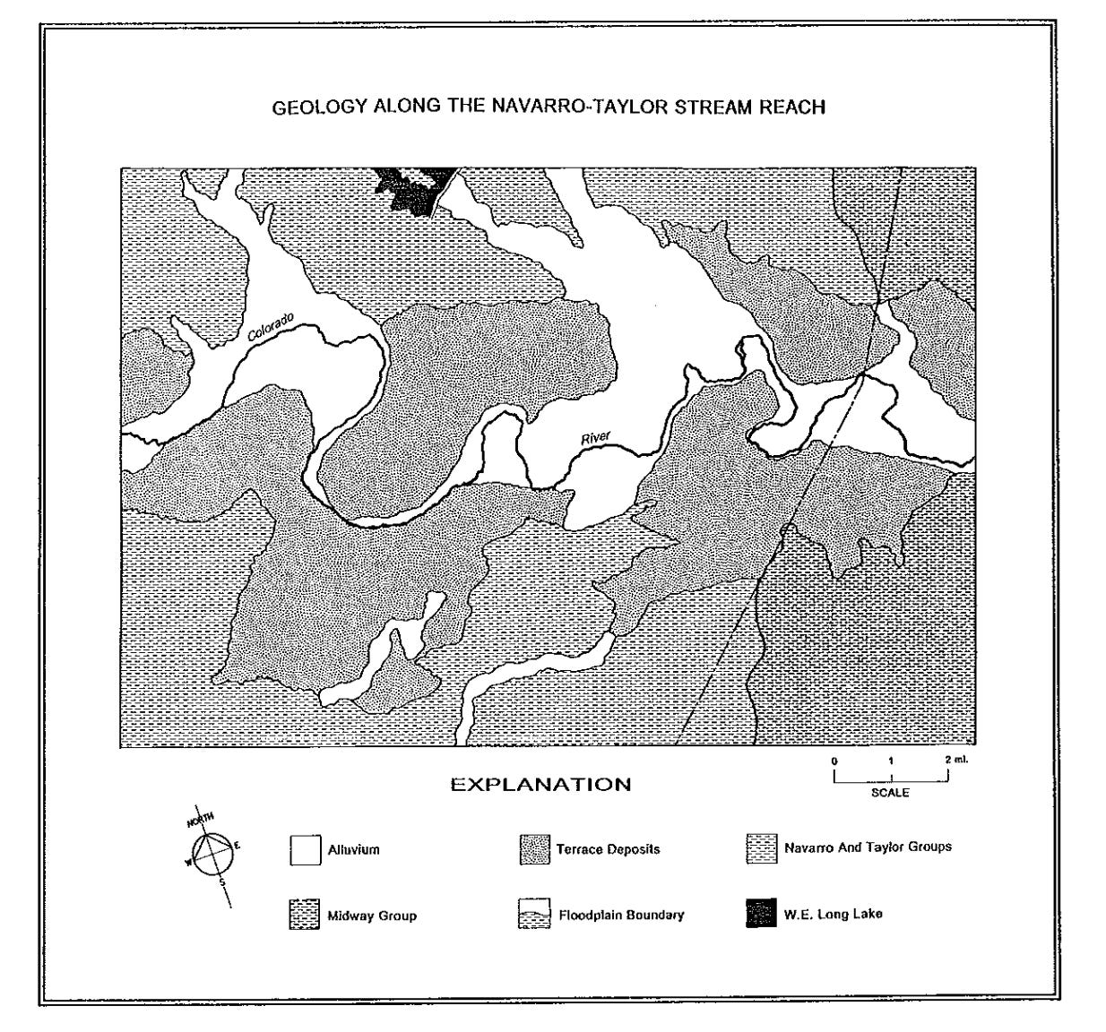
Active wells pulling from the Trinity Aquifer are drilled to 600 to 1200ft deep - that’s the layer where the Trinity Aquifer is. Further south and east the Trinity continues to get deeper underground. Here’s a well a few miles east by Walter E Long Lake that was drilled to 3250ft:
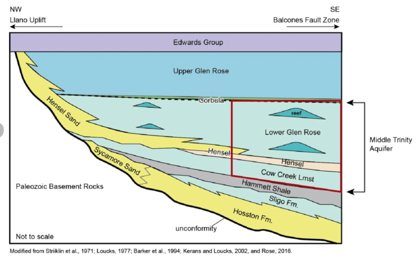
Here’s a rough cross-section of the aquifers underneath Austin.
There are a couple wells in the Dog’s Head area, let’s check how deep they are.
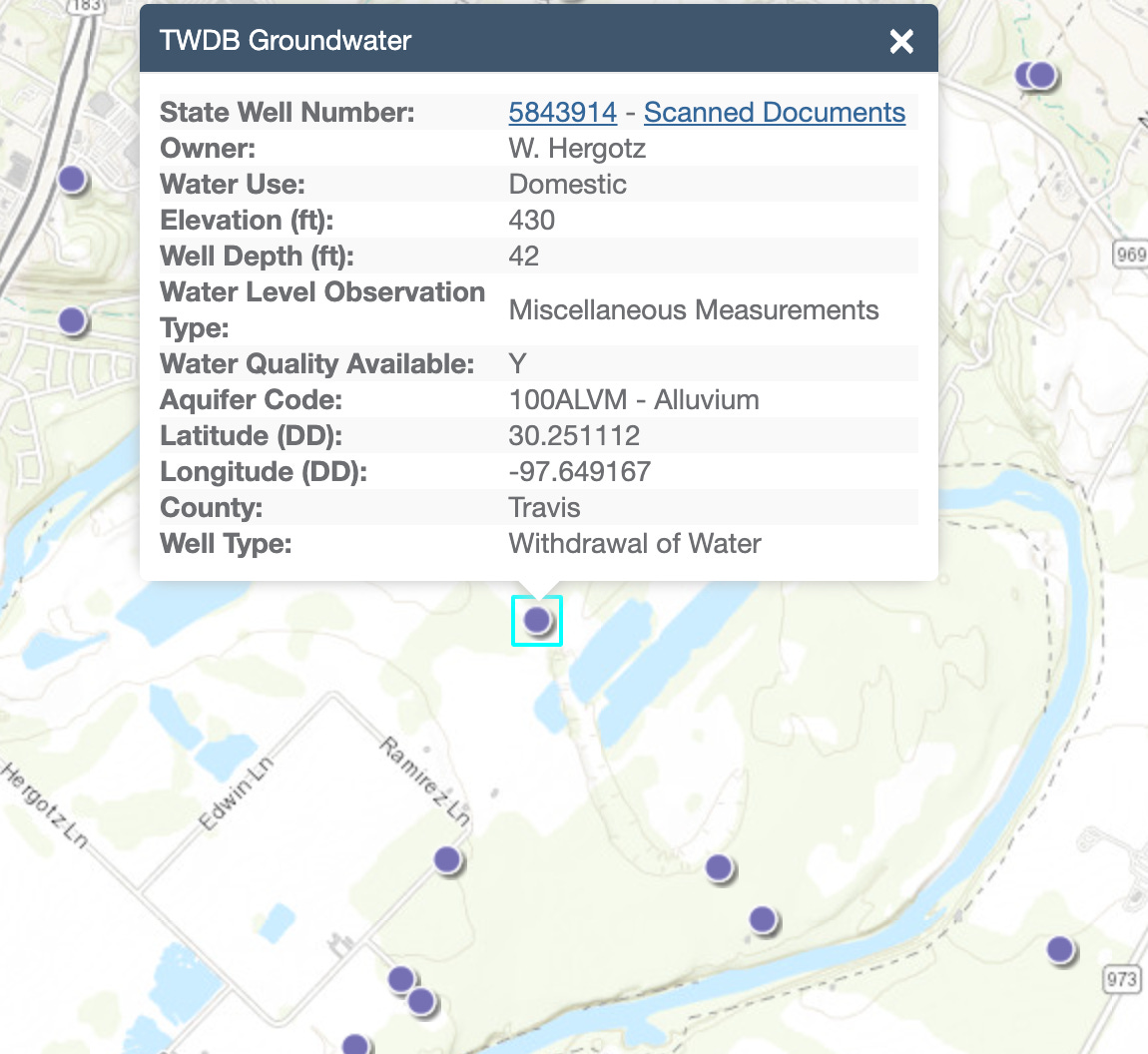
42 feet??
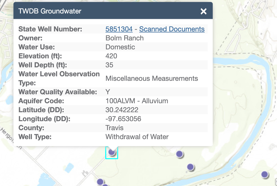
35 feet?!
What on earth?
In Texas, where water tables have been plummeting across the entire state for the last 100 years - there’s wells that only needed to be drilled to 35 feet?
These are old wells, maybe back in 1970 the water level was above 35 feet, but its almost inconceivable for that to hold true today.
And yet - here’s a well dug there in 2013, and the water level was measured at 29.8ft.
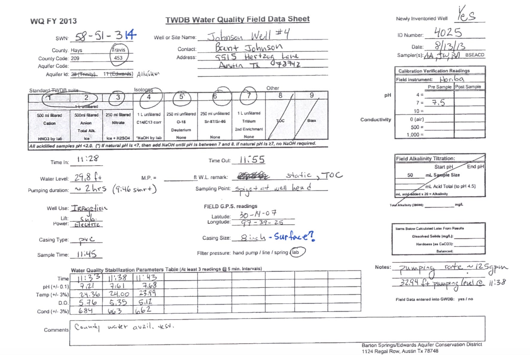
Boys there’s water in this here ground. And it’s right there.
This doesn’t quite fit with the common understanding of the water cycle here in Texas. Usually it goes something like this: Water comes down as rain, and heads for the nearest river. If it moves slowly towards the river, some is absorbed and trickles down to recharge the aquifers, it it moves quickly towards the river, it erodes the soil and brings sediment with it. Once it gets to the river, it heads for the ocean. It can be captured and held in lakes and reservoirs, where it also charges the aquifers. Once it’s downstream, it’s gone.
Any water that’s absorbed around here should make it to the Edwards aquifer around 300-600 feet, or deeper to the Trinity. We don’t expect it to be hanging out at around 30 feet. That’s every rancher’s and farmer’s dream come true, and hasn’t been seen in Texas since the very first cities were built. Cities came, wells were dug, and water tables plummeted. We’ve slowed the freefall recently, but not stopped it.
And yet - 30 feet down, there’s still water in Dog’s Head.
The answer, which you may find to be obvious, is that we’re in a river. A river isn’t just the surface water we can see, but a saturated zone around it. This isn’t always true though - the Lower Pecos cuts through the Devil’s Canyon, not much water in them rocks.
Similarly and closer to home, the Llano river cuts through bedrock.

Worth noting the bedrock here is limestone - that old ancient seabed we talked about before:
This porous old limestone is how water is held throughout the rest of Texas, but not right here on Dog’s Head - something else is holding the water close to the surface.
Let’s dig deeper….
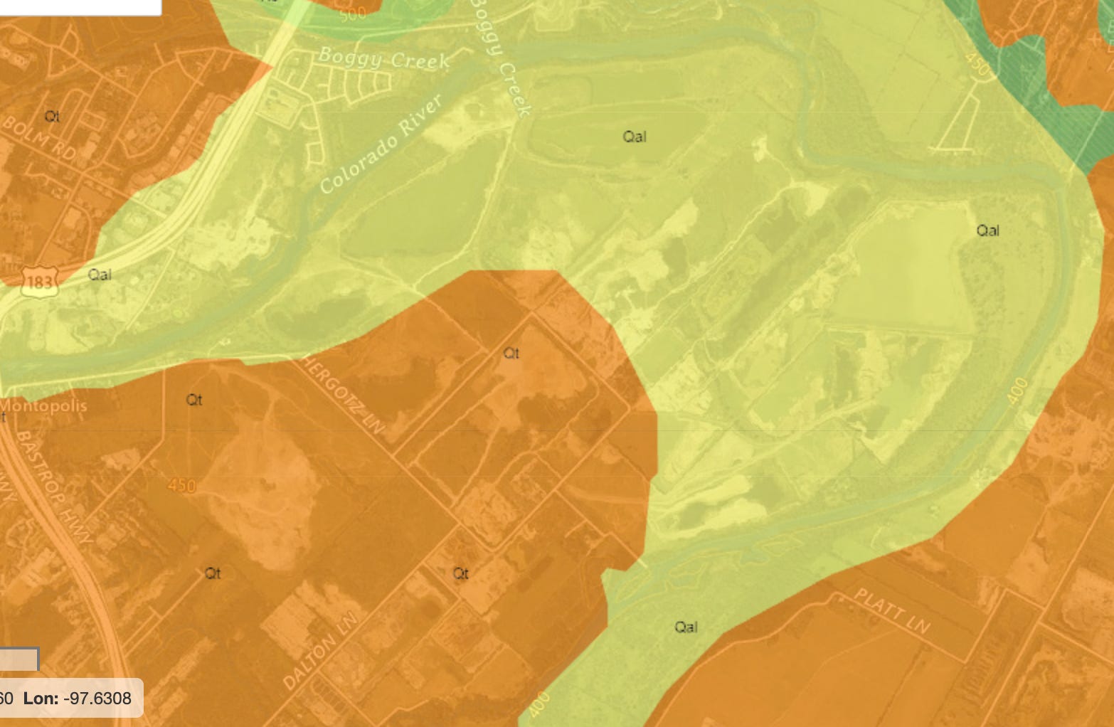
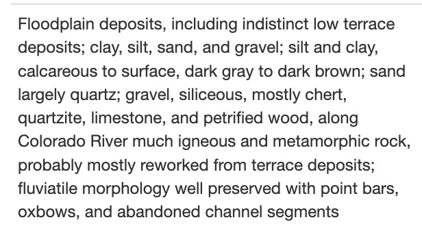
The geology of Dog’s Head consists of two types, the light yellow is:
And the orange color is:
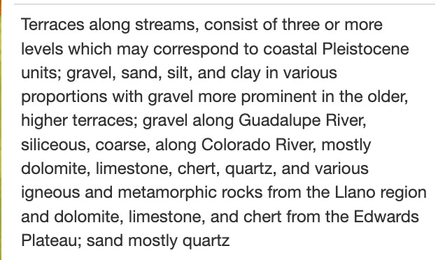
Okay - that makes sense why this area was mined. It’s gravels, silts, sands, clays, and more that have been deposited - this is the wash of mixed sediments from the Colorado river that have been left here from flood events over the last several thousand years. The Colorado river comes coursing down through the rocky Hill Country, hits the lowlands, and fans out - bringing all the flood sediments, rocks, and nutrients with it.
The well diggers noted what they were digging through -

30 - 60 feet of water-bearing sand and gravel.

And when Brent Johnson dug his well, he noted the aquifer:
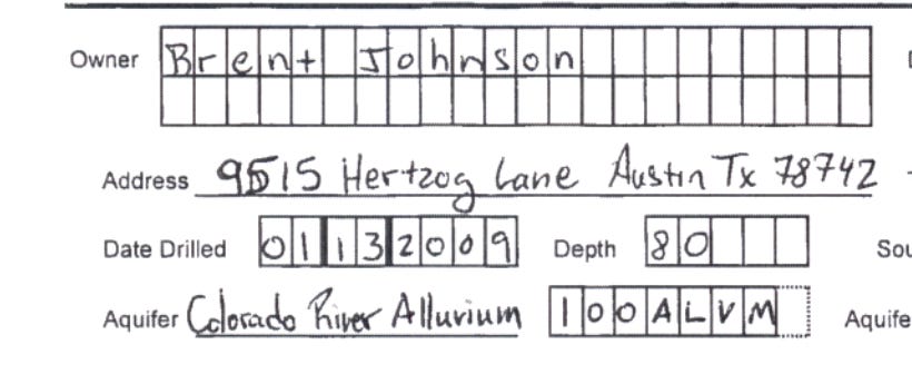
Colorado River Alluvium.
That’s not an aquifer name that’s on any maps. What is it? Where is it? How’s it work?
The Colorado River Alluvium
I’m not the first to notice this, what a surprise that would be. The University of Texas created a 121 page report for the LCRA in 1991, the year before I was born.
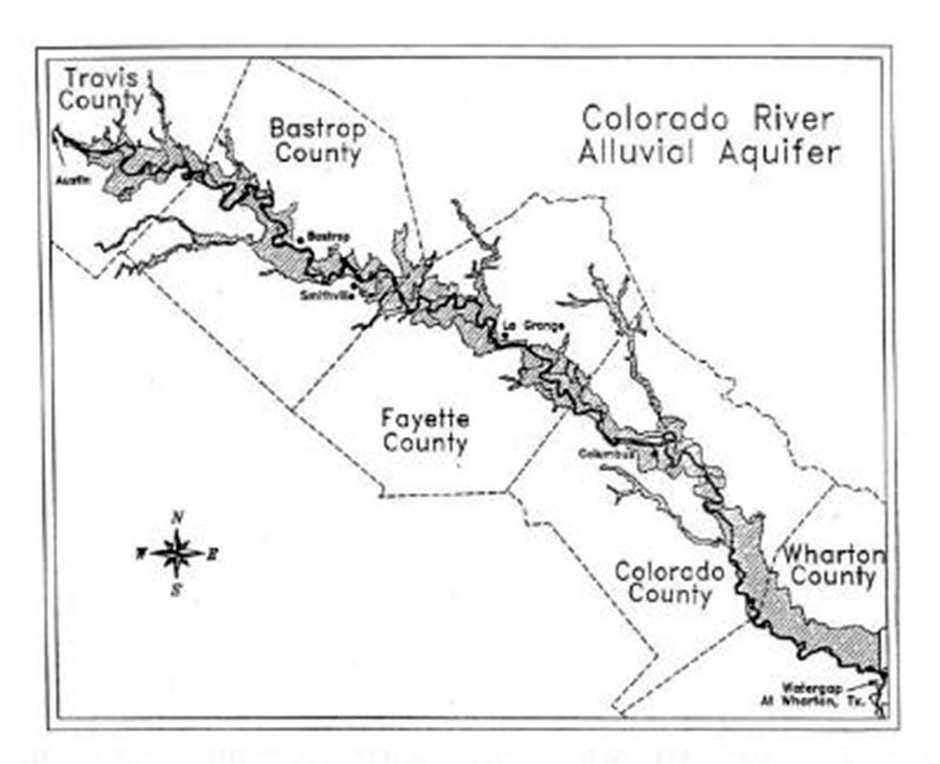
They mapped it - it starts in Austin, and continues at varying widths down past Smithville, then on to the Gulf.
Here is another map, from back in ‘74:
In 1996 a paper was published, the abstract reads:
The Colorado River Alluvium has characteristics which qualify it for designation as a minor aquifer by the Texas Water Development Board, although the TWDB has not yet made such a designation. Without recognition as a significant water supply in the state, this resource is vulnerable to pollution and diminution. Major and minor aquifers in Texas were redefined by the TWDB as an update to the Texas Water Plan in 1990. The Brazos River Alluvium was separated from other Quaternary deposits and designated as a minor aquifer because of its importance as a water supply for irrigation use. No other alluvial aquifers have been recognized as significant water supplies in Texas. The Colorado River Alluvium stretches for 200 miles (322 km) from Austin to Wharton, Texas. Water-bearing formations farther downstream are grouped into the Gulf Coast Aquifer. Water in the alluvial aquifer is in direct contact with the Colorado River and has similar water quality characteristics as the river, which is now considered exceptional for aquatic life. Since some communities use the alluvial aquifer for municipal water supply, it is important that groundwater be of high quality.
The Brazos River Alluvial Aquifer has been found to be highly vulnerable to pollution. Using the same assessment criteria, the Colorado River Alluvial Aquifer would also be deemed to be vulnerable to pollution.
At the very beginning of this 200 mile stretch of water-giving, life-giving alluvial plain, the Dog’s Head:
Dog’s Head is quite literally at and on the headwaters of this loosely connected shallow aquifer. It’s the drinking water for Bastrop, and is used widely from here to the Gulf.
And Austin’s sitting right at the top of this thing? Score!! And we recharge it with our own excess water? Score again!
Dog’s Head development could be one of the most consequential land-use decisions in Austin’s history, and the city is poised to move forward without understanding what it is, or what it could be.
What to do with it?
Well, first and foremost - we can’t poison it. Remember that contract I mentioned earlier? The one they just signed, and lasts for 45 years? Here are the permitted land uses. Spoiler - the developer didn’t rule anything out (at all).
If anything truly toxic gets into this water, the residents of Bastrop are quite literally drinking it. Not filtered through vast limestone filtration like most groundwater - it’s going a few miles downstream and up into their shallow wells.
But is don’t poison it and murder our neighbors really the bar we’re aiming for?
We have an alluvial floodplain on our hands! Throughout history, civilizations have flourished on alluvial floodplains because they combine fertile soils, abundant water, and natural transportation corridors. You have the trifecta of human flourishing, the needs of any civilization, all easily accessible: food, water, shelter.
At a time in central Texas, where water resources are getting scarce, food supply chains are long and less reliable and more expensive, and climate change is threatening to make the entire area less habitable over the coming centuries - can we think of anything better than Mixed Use & Advanced Manufacturing? Is a Fortune 100 “anchor tenant” our highest ambitions for this area?
This alluvial floodplain could be, if managed and harnessed well and wisely, the salvation of our entire region.
Prudence & Stewardship
“A society grows great when old men plant trees whose shade they know they shall never sit in” goes an old Greek proverb.
Pair it with an ancient Chinese one: “The best time to plant a tree was 20 years ago. The second-best time is now.”
I love this city. An oasis of life, and love, joy, music, nature, and beauty. I think ahead not just 45 years in the future, but what happens in 100 years, in 200 years? Will our great-grandchildren swim and sing in Barton Springs, will Austin and the Texas Triangle survive the coming droughts, storms, floods, and heatwaves? What must we do today so that our great-great-grandchildren will sing our praise?
To me, the answer is obvious. Yes, the city should get some new and much needed tax revenue from a new annexation and its subsequent development. Yes, the developer should develop this area, and make a tidy profit from it. But what the city really needs from this area, not for this budget cycle or next, is food, water, shelter.
That’s it. That’s my argument. If you’ve made it this far, I encourage you to sit on that. What does wise usage of this land mean? What does generational-thinking, and prudent stewardship look like in this context? How can we move forward balancing the needs of the city, the developer, the citizenry of the city, the many animals of the river, the health of the river itself, the quality of the water, and the region’s present and future needs for water, food, and resources?
I don’t know the exact answer to that.
There’s a strong case for water.
There’s a strong case for housing.
There’s a strong case for transit.
There’s a strong case for farming.
I plan to come back and add links, fleshing out some of my ideas for what each of those could look like. Mexico city invented an urban food production system called chinampas, Venice found a way to build steady foundations in a swamp, and create their own rainwater filled cisterns producing artisanal wells, ancient cities around the world have long used bricks made of local earth to build lasting structures that are passively cooled, and survive the elements, but the best use of this land can only be found with collective and communal effort.
Truth be told, I don’t know what that best use will look like. I’m just one guy. I’m not a hydrologist, planner, or engineer. I’m simply a guy that loves living in Austin, exploring the rivers and parks, and became convinced that Dog’s Head deserves more attention than it’s getting.
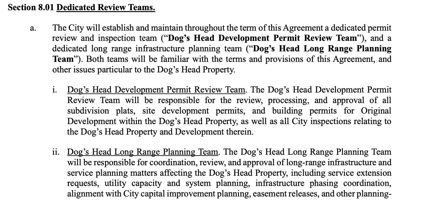
Right now - this thing is moving really fast. The city has 30 days from the date of signing, May 21st, to create two teams, a special Permit Review team, dedicated to reviewing permits for developments in the Dog’s Head area, and a Long Range Planning Team.
Here are some things that seem to make sense to me, but honestly, you should help me come up with more. This is the audience participation section of this essay. Send me ideas, build coalitions, rouse the rabbles, and let’s make an actual plan for this puppy.
I think it is essential that these two teams, and especially the Long Range Planning Team, include members of the LCRA, responsible for managing this downstream section of the Colorado river. To exclude them from this seems to circumvent their authority and responsibility. It is also essential to include on these teams members of the local community, and the organizations which represent them (Colorado River Alliance, Austin Permaculture guild). It seems like it would also be wise to include members from A&M and UT to provide academic expertise.
What to do
First - email City Council right now, using this form, and say something like “we need transparency and input on the permitting team and long term planning team for Dog’s Head, which sits at the top of the Colorado River alluvial aquifer. The LCRA, Colorado River alliance, and departments from A&M and UT, as well as local community leaders, need to be included on that team. Please schedule an agenda item immediately to discuss how these members are chosen, and to provide more information about these teams that will make important decisions regarding one of the most underutilized and overlooked water resources for this city and the Central Texas region as a whole.”
Then, send this to your friends, especially those involved in relevant organizations. Somehow this whole Dog’s Head development has completely flown under the radar. Articles were barely hitting the press by the time city council voted to approve the contract. We need eyeballs on this thing, we need awareness: help get the word out that this is a big deal, a monumental, and SO EXCITING development for the City of Austin. Everyone that lives here should be absolutely psyched about this annexation, and for everything it could represent.
Last, send me a message, leave a comment, and, better yet - come meet up at Batch Coffee this Saturday June 13th from 2pm - 6pm to chat in person.
Thanks for reading!